National Meteorological Center issues dual warnings as Typhoon Podul slams China with heavy rainstorms
The center of the year's strongest typhoon, Typhoon Podul, made a second landfall in the coastal area of Zhangpu county, East China's Fujian Province, around 12:30 am on Thursday, with maximum winds of Force 11 near its center. After the landfall, Podul is expected to slow down, bringing significant wind and rain to South China's Guangdong Province and Guangxi Zhuang Autonomous Region, Central China's Hunan Provinces, Southwest China's Guizhou Province, and other regions.
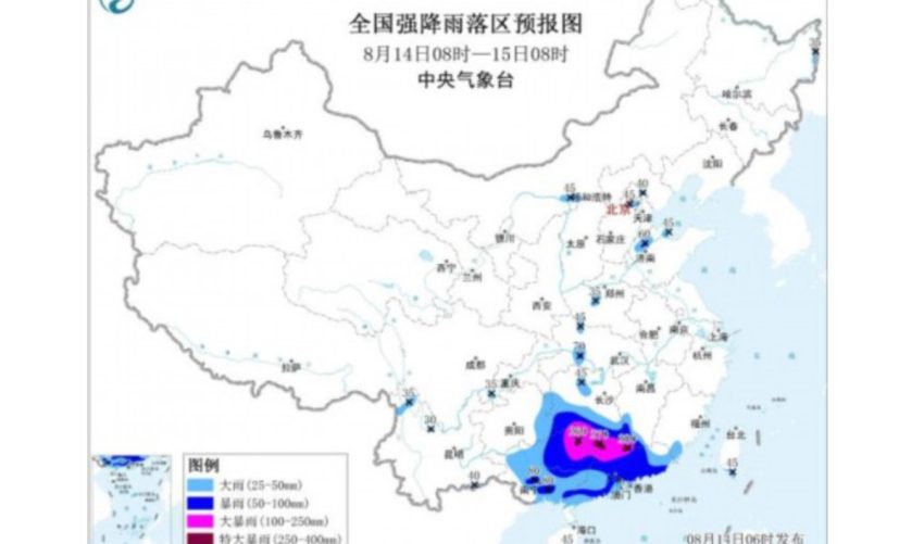
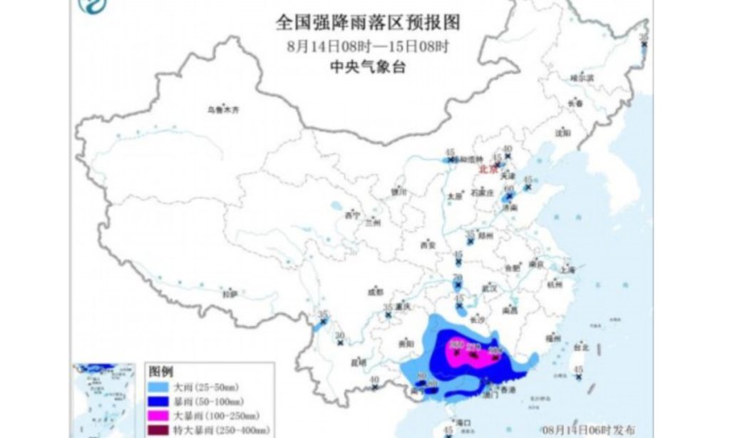
On Thursday, Podul's heaviest rainfall hit Guangdong, Guangxi and southern Hunan, with Guizhou and other regions impacted on Friday. It is important to note that after entering Guangxi, the remnants of Podul will slow down, leading to prolonged rainfall and high cumulative precipitation in northern Guangxi and southern Hunan, raising the risk of secondary disasters.
According to the website of the National Meteorological Center, at 6 am on Thursday, the center issued an orange alert for heavy rain and a blue alert for typhoons.
In response to the wind and rain from Podul, cities in eastern Guangdong have swiftly mobilized, applying the highest standards and strictest measures to typhoon prevention. Chaozhou, Shantou and Jieyang have together relocated over 18,000 people, China National Radio reported on Thursday
The Department of Transport of Guangdong Province on Thursday completed the evacuation of personnel from offshore fishing vessels, aquaculture rafts, marine ranches and offshore wind power construction platforms. The Department of Transport of Fujian Province has coordinated with transportation bureaus in six coastal prefecture-level cities to oversee the implementation of all typhoon prevention measures. Emergency response teams have been pre-positioned at 861 high-risk road sections, with 77 teams deployed, and 84 teams stationed at 323 sites prone to flooding from mountain torrents. Emergency personnel in the port, shipping and transportation systems remain on standby.
Facing severe challenges in typhoon and flood prevention, regions and departments across Guangdong have taken proactive steps in forecasting and early warnings. Earlier on Tuesday and Wednesday, the Guangdong Meteorological Service, together with multiple departments, sent typhoon prevention information to mobile phone users across all 21 cities in the province, reaching approximately 380 million person-times via the provincial emergency warning information release platform.
Meanwhile, multiple departments promptly initiated emergency responses. Since Tuesday, the Guangdong Provincial Flood Control Headquarters has activated and repeatedly upgraded its wind prevention emergency measures, currently maintaining a level II emergency response. All regions and departments have been ordered to accelerate the relocation of people from hazardous areas and complete all evacuations by 6 pm on Wednesday, ensuring everyone who needs to be moved is relocated as early as possible.
The city of Chaozhou enacted the "five suspensions" measure including suspending classes, work, production, transport and business operations citywide starting at 11pm on Wednesday, except for essential services such as water, electricity, gas, communications, medical care and disaster relief units. Shelters were opened for residents to take refuge. During the suspensions, the public was advised to stay indoors and avoid unnecessary outings.
By Wednesday daytime, Podul's rainfall had begun over the Taiwan island and the coastal areas of Fujian and Guangdong. By 2 pm on Wednesday, some areas in Taiwan's Pingtung and Taitung recorded over 200 millimeters of rainfall in six hours, with gusts reaching Force 13-14 and exceeding Force 17 on Lanyu island. Additionally, coastal areas of Fujian experienced gusts of Force 8 or higher. The typhoon forced suspension of the Xiamen-Kinmen and Quanzhou-Kinmen ferry routes, and cancellations on the Beijing-Guangzhou, Beijing-Kowloon, Hangzhou-Shenzhen, Ningbo-Guangzhou and Meizhou-Shantou railways.
"Landfall does not mean the danger is over. In the coming days, Podul will move inland and bring significant rainfall to multiple provinces," said Sun Qianqian, a meteorological analyst at Weather China. Due to surface friction and reduced energy supply from the sea, the typhoon will gradually weaken after landfall but will continue to bring heavy rainfall to Guangdong, Guangxi, Hunan and other areas. Later, influenced by easterly airflow on the southern side of the subtropical high, Podul will track westward, with its remnants possibly entering Guizhou and dissipating or moving into the Sichuan Basin before gradually fading, according to Sun.